TITLE: Eco-Corridor
PRIZE: 1st Prize
COMPETITION: Regeneration and Reuse of former lignite mines in the Western Macedonia region
CLIENT: DEH (Public Power Corporation S.A. of Greece)
LOCATION: former lignite mines in Ptolemaida area, Greece
SURFACE: 188,737 ha
YEAR: 2016
FIRM: topio7
EXTRA distinctions: International Award in the Category of Non-Implemented Landscape
Architectural Projects at the 7th International Landscape Architecture Exhibition 2017 organized by the Serbian Association of Landscape Architects – Belgrade, Serbia
DESIGN TEAM:
AUTHORS:
topio7 : Katerina Andritsou – Panita Karamanea – Thanasis Polyzoidis
COLLABORATORS-3d Visualization (in collaboration with topio7/Thanasis Polyzoidis):
Chrisanthi Vathi,architect, Lida Driva,architect, Adamantia Samiou , architect, Lela Chronopoulou, student of architecture


The current typical inland landscape of Western Macedonia, although changed through human made actions, has preserved its beauty with dominant natural elements and interesting views. It is however, characterized by fragmentation, access difficulty and discontinuities. This landscape needs
This landscape needs a mild project gesture in order to be enhanced, environmentally and aesthetically improved and become a public attractive place.

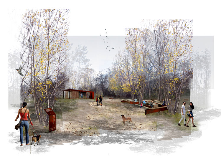
The concept derives from the longitudinal site’s shape that could function as an ecological corridor. The need for environmental enrichment and biodiversity, has led to a system of fluxes that organizes spatial relationships and connects habitats. The resulting landscape is being crossed by a series of ecological itineraries – the ‘eco_corridors’ with different characters, qualities and uses: cultural uses, sport – leisure facilities that offer economic benefits.

Main aim of the project is to maintain the special atmosphere of the place, by unifying and integrating through scales. The project acts as a strategy that is being expressed in three thematic axes: (i) biodiversity and ecological connectivity (ii) water net management (iii) evolution through time (iv) spatial organization of movements and stops, v) new uses on local and supra-local character.

The interpretation of the existing section and the topography, emphasizing in the individual special spatial qualities of the place, has played a significant role.
The empty space between the individual landscape areas has been considered as a spatial and ecological virtue to be maintained. The movement and rest area network has been designed to be embedded in the relief and the individual spatial qualities, providing variety between enclosed and extrovert areas and viewpoints.

The proposal is structured in various landscape zones and intermediate transition zones with characterized spatial identities such as:
- the athletic park (sports activities, racing circuit in the forest, playgrounds, recreation, parkings)
- the spectacles’ place (amphitheater embedded in the landscape, existing motocross)
- The Conifer forest (net of movement and rest areas – picnic areas, belvederes)
- the cultivations (extensive timber, nurseries, fruit trees, ecological orchards)
- the riparian forest (net of movement, rest areas – picnic areas, social games, recreation)
- The central meadow (lineal guarrigue gardens, places for social happenings, clearings of natural regeneration, outdoor activities, marketplaces , exhibition of sculptures and industrial installations as “objects trouvés¨)
- the Robinia pseudoacacia forest (net of movement and rest areas – picnic areas, adventures park, belvederes)
- the artificial wetlands aiming to irrigate the whole area (rainwater deposits, macrofita)
- the hills (main viewports – belvederes for the whole area and the observation of the fauna)
Plantation being a main structural element of the place, is being used as an entrance marker, a filter, a mantle, in masses giving birth to enclosed or extrovert landscapes, to densities and clearings.

It is a hybrid proposal that combines heritage and ecology to a new model of conservation for patrimonial European landscapes through design intervention.
For more details visit: https://www.facebook.com/topio7architects/


